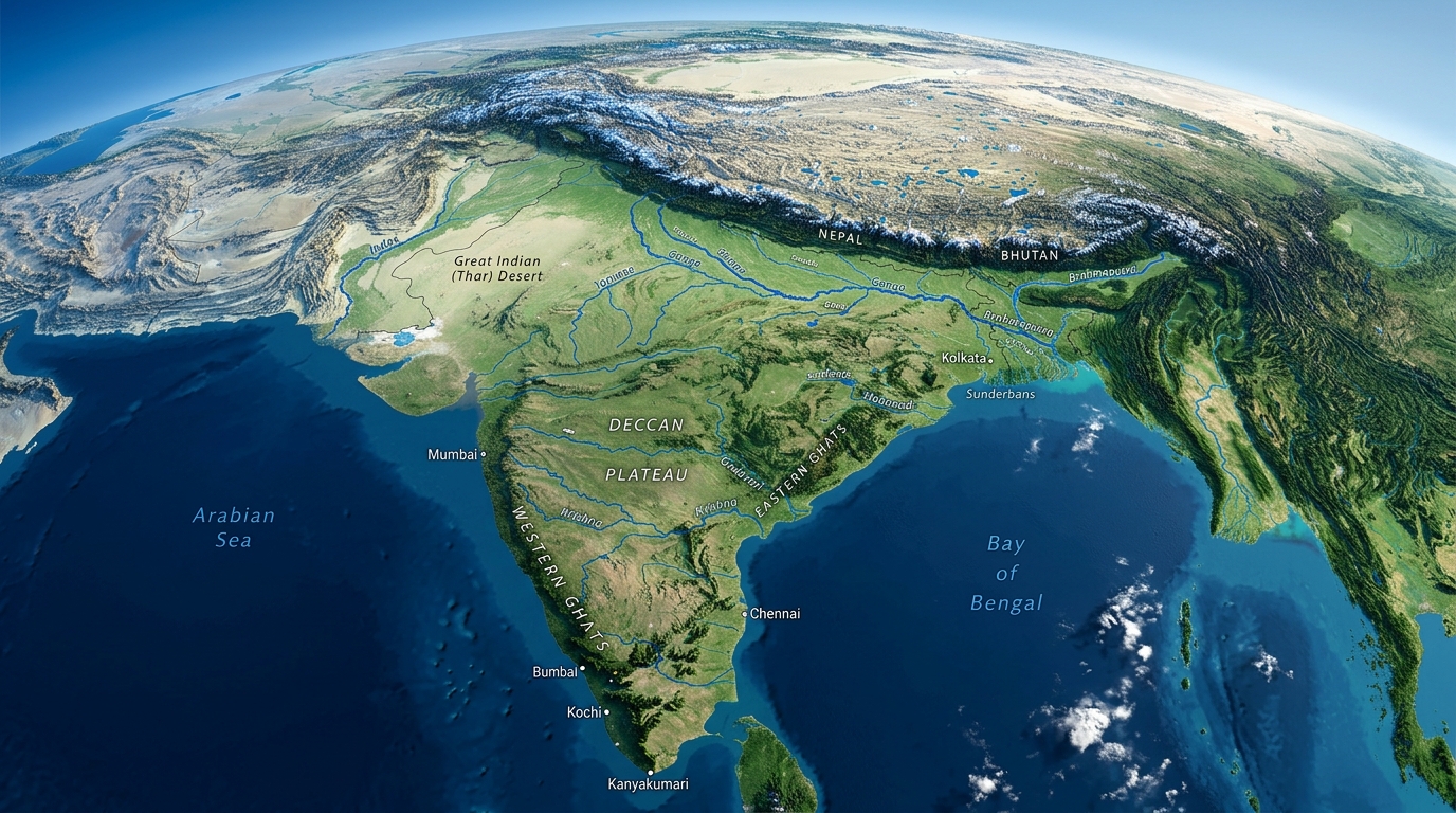
India is one of the most geographically diverse countries in the world. From the permanently snow-covered Himalayan peaks in the north to the tropical coral islands in the south, India encompasses an extraordinary range of landscapes within a single country.
With a total area of 3.287 million square kilometres, India is the seventh-largest country in the world by area and is home to almost every type of physical geography on Earth.
Overview: India's Location
India lies in South Asia, occupying a large peninsula that extends into the Indian Ocean. It is bounded by:
- North: The Himalayas, forming a natural barrier with China, Nepal and Bhutan
- North-West: Pakistan
- North-East: Bangladesh, Myanmar
- West: Arabian Sea
- East: Bay of Bengal
- South: Indian Ocean, with Sri Lanka across the Palk Strait
The Six Major Physical Regions of India
India can be divided into six distinct physical regions, each with its own landscape, climate and characteristics.
1. The Himalayan Mountain Region
The Himalayas form the northern and north-eastern boundary of India. Stretching over 2,500 km, they are the world's highest mountain system.
- Contains 10 of the world's 14 peaks over 8,000 metres
- Home to Mount Kanchenjunga (8,586 m), India's highest peak
- Divided into three parallel ranges: Greater Himalayas, Lesser Himalayas and Outer Himalayas (Siwaliks)
- Source of major rivers including the Ganga, Yamuna, Indus and Brahmaputra
- Acts as a natural climate barrier, blocking cold Central Asian winds
2. The Northern Plains (Gangetic Plain)
The Indo-Gangetic Plain, or Northern Plain, is one of the world's largest and most fertile alluvial plains. It stretches from Punjab in the west to Assam in the east.
- Formed by the deposition of sediments from the Himalayan rivers over millions of years
- The most densely populated region of India — home to over 40% of the population
- Extremely fertile and the agricultural heartland of India
- Major cities: Delhi, Lucknow, Patna, Varanasi, Kolkata
3. The Peninsular Plateau (Deccan Plateau)
The Deccan Plateau is the large elevated highland that forms the heart of peninsular India. It is one of the world's oldest rock formations.
- Average elevation of 600–900 metres above sea level
- Rich in mineral resources: iron ore, coal, copper, bauxite
- Bounded by the Western Ghats on the west and Eastern Ghats on the east
- Drained by rivers flowing east: Godavari, Krishna, Kaveri
4. The Coastal Plains
India has 7,516 km of coastline, divided into two distinct coastal plains:
| West Coast | East Coast |
|---|---|
| Narrower (10–25 km wide) | Wider and more regular |
| Bordered by Western Ghats | Bordered by Eastern Ghats |
| Major ports: Mumbai, Kochi, Goa | Major ports: Chennai, Visakhapatnam |
| Receives heavy rainfall (monsoon) | Drier, rain from north-east monsoon |
| Known for lagoons (Kerala backwaters) | Known for river deltas (Godavari, Krishna) |
5. The Indian Desert (Thar Desert)
The Thar Desert, also called the Great Indian Desert, occupies the north-western part of India, primarily in Rajasthan. It is the 9th largest desert in the world.
- Covers approximately 200,000 sq km
- Extremely hot and arid — one of the most densely populated deserts in the world
- Contains the towns of Jaisalmer, Bikaner and Jodhpur
- Home to unique wildlife including the Great Indian Bustard
6. The Island Groups
India has two major island territories:
- Andaman and Nicobar Islands — In the Bay of Bengal. Volcanic origin. Dense tropical rainforests. 572 islands, of which 37 are inhabited.
- Lakshadweep — In the Arabian Sea. 36 coral islands. India's smallest Union Territory.
Mountain Ranges of India
| Range | Location | Highest Peak |
|---|---|---|
| Himalayas | North India | Kanchenjunga (8,586 m) |
| Karakoram | Jammu & Kashmir | K2 (8,611 m) — shared with Pakistan |
| Aravalli Range | Rajasthan, Delhi | Guru Shikhar (1,722 m) |
| Vindhya Range | Central India | Up to 1,000 m |
| Satpura Range | Central India | Dhupgarh (1,350 m) |
| Western Ghats | West coast, Kerala–Gujarat | Anamudi (2,695 m) |
| Eastern Ghats | East coast, Tamil Nadu–Odisha | Jindhagada (1,690 m) |
| Shillong Plateau | Meghalaya | Shillong Peak (1,966 m) |
Frequently Asked Questions
Conclusion
India's geography is extraordinary in its diversity. Within a single country, you can find the world's highest mountains, one of the world's greatest river plains, ancient volcanic plateaus, tropical rainforests, hot deserts, mangrove swamps and coral islands. This geographical diversity has profoundly shaped India's climate, agriculture, cultures and history.
Related: Major Rivers of India · Himalayan Mountains · Indian Monsoon